Log in
All resources
Create a design
33,222 Free Images of Elevation Map
bibliothèque nationale de france
john rocque
map of the circle of the rhineland by sanson
john rocque's 1748 map of london and adjacent country
pages with maps
cc-zero
reconstruction of ruysch's africa map by stanley
curt teich postcard archives
map collection of leibniz-institut für länderkunde
map of amsterdam by gerrit de broen (ii)
map of ancient asia minor by philippe de la rué
1650s maps of turkey
map of the german empire by louis stanislas d'arcy de la rochette
1780s maps of lithuania
reconstruction of ruysch's africa map by stanley
new light on dark africa (dulcken)
reconstruction of ruysch's africa map by stanley
dans les ténèbres de l'afrique (1890)
reconstruction of ruysch's africa map by stanley
im dunkelsten afrika (1890) by wobeser
john and sebastian cabot. a study (1886)
map of juan de la cosa
reconstruction of ruysch's africa map by stanley
stanley in afrika's donkere wildernissen (1890)
reconstruction of ruysch's africa map by stanley
im dunkelsten afrika (1890) by wobeser
maps of paris from the david rumsey historical map collection
maps of île-de-france by françois de la guillotière
20th-century maps of illinois
curt teich postcard archives
early netherlandish painting
t and o map
19th-century maps of bohemia
maps of regions of bohemia
john rocque's 1748 map of london and adjacent country
bibliothèque nationale de france
john rocque's 1748 map of london and adjacent country
bibliothèque nationale de france
map of amsterdam by gerrit de broen (ii)
bibliothèque nationale de france
john rocque's 1748 map of london and adjacent country
bibliothèque nationale de france
john rocque's 1748 map of london and adjacent country
bibliothèque nationale de france
map of amsterdam by gerrit de broen (ii)
bibliothèque nationale de france
john rocque's 1748 map of london and adjacent country
bibliothèque nationale de france
map of amsterdam by gerrit de broen (ii)
bibliothèque nationale de france
john rocque's 1748 map of london and adjacent country
bibliothèque nationale de france
john rocque's 1748 map of london and adjacent country
bibliothèque nationale de france
map of vienna by jacob hoefnagel
roter turm, vienna
john rocque's 1748 map of london and adjacent country
bibliothèque nationale de france
map of vienna by jacob hoefnagel
roter turm, vienna
map of amsterdam by gerrit de broen (ii)
bibliothèque nationale de france
1801 map of turkey in asia by john cary
1801 maps of the ottoman empire
postcards with 2 images
map postcards
amsterdam in the 1540s
agnietenkapel
turgot map of paris, kyoto university library – derivative files
couvent des capucines
old maps of the tuamotus
old maps of polynesia
old maps of the london borough of tower hamlets
maps by john pine
old maps of the principality of minden
1840s maps of north rhine-westphalia
map of brugse vrije by pieter claeissens de jonge
drawings in the groeningemuseum
16th-century maps of the indian ocean
renaissance
map of the upper rhenian circle by sanson
maps by nicolas sanson
map of the upper rhenian circle by sanson
maps by nicolas sanson
san giovanni battista (venice giudecca)
demolished churches in de barbari map
coats of arms of the tsardom of russia
details of sigismund's map of moscow
self-published work
rural
self-published work
architecture
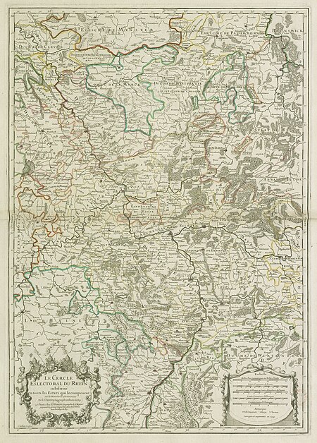
map of the circle of the rhineland by sanson
1670s maps of rhineland-palatinate
map of the circle of the rhineland by sanson
1730s maps of rhineland-palatinate
map of the circle of the rhineland by sanson
1680s maps of rhineland-palatinate
map of the circle of the rhineland by sanson
1730s maps of rhineland-palatinate
map of the circle of the rhineland by sanson
1700s maps of rhineland-palatinate
map of the circle of the rhineland by sanson
1700s maps of rhineland-palatinate
map of the circle of the rhineland by sanson
1730s maps of rhineland-palatinate
map of the circle of the rhineland by sanson
1730s maps of rhineland-palatinate
map of the circle of the rhineland by sanson
1680s maps of rhineland-palatinate
self-published work
pages with maps
blue coat school, dublin
1906 books
maps of the duchy of mantua
guillaume sanson
maps of paris from paris musées
baroque
self-published work
roppongi hills
self-published work
architecture
postcards of st. louis, missouri
curt teich postcard archives
collections of the amsterdam museum
hasan çolpan
john rocque's 1746 map of london
old and new london (book)
prints by cornelis anthonisz. in the rijksmuseum amsterdam
map of amsterdam, 1544
postcards of ottawa county, oklahoma
curt teich postcard archives
maps of paris from the david rumsey historical map collection
environs de paris levés géométriquement by jean delagrive
map of modern syria by philippe de la rué
1650s maps of palestine
map of the circle of austria by sanson
context files from gallica
old maps of the london borough of southwark
john rocque's 1746 map of london
ethnographic maps of austria-hungary
1890s maps of austria-hungary
turgot map of paris, kyoto university library – derivative files
enclos saint-lazare
maps of amsterdam in the rijksmuseum amsterdam
map of amsterdam, 1544
map of maastricht by willem and johannes blaeu (1649)
jezuïetenwal (maastricht)
france in the 1690s
old maps of france
map of ghent by folkema, harrewijn, 1785
collections of ghent university library
stedenboeken van de wereld by johannes janssonius 1657
map of ghent by jan blaeu
map of ghent by lucas de heere
collections of archief gent
margraviate of moravia (1628-1782)
coats of arms on maps
john rocque 1746 london map (a1-h3)
st george's fields, southwark
eran laor cartographic collection
afbeeldinge der stad jerusalem
arnold van langren map of southwest africa
renaissance
maps by edward wright
molyneux globes
map of the german empire by louis stanislas d'arcy de la rochette
1782 maps of the holy roman empire
map of bruges by marcus gheeraerts (i)
drawings in the groeningemuseum
historical images of place du carrousel
rue saint-nicaise (paris)
map of paris by braun & hogenberg - derivative files
pont aux meuniers
map of paris by braun & hogenberg - derivative files
le marais
brazilian paintings in the museu antônio parreiras
textile and oil painting on canvas
steinfels collection
engravings of bern
demolished churches in de barbari map
sant'agostin (venice)
brazilian paintings in the museu antônio parreiras
textile and oil painting on canvas
demolished churches in de barbari map
sant'angelo (venice)
maritime history of india
sailing ships of india
postcards of oklahoma county, oklahoma
curt teich postcard archives
curt teich postcard archives
afton, oklahoma
map of maastricht by willem and johannes blaeu (1649)
atlas beudeker
self-published work
pages with maps
self-published work
rural
map of ancient assyria by philippe de la rué
old maps of mesopotamia
turgot map of paris, kyoto university library – derivative files
foire saint-germain on old maps
maps from traité de la police, bibliothèque nationale de france
fourth map of paris from traité de la police
16th-century maps of amsterdam
lodovico guicciardini
map of the circle of the rhineland by sanson
maps by nicolas sanson
self-published work
elevator button
2601 - 2700 of 33,222
Next page
/ 333


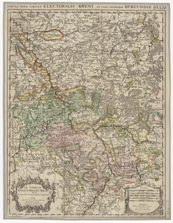


![The Electoral Circle of the Rhine subdivided into all the Estates which compose it... / by Sanson, ,... Geometric Miles or Miles of Italy [30 = 12] common leagues of France, 1734](https://cdn.creazilla.com/illustrations/10001532968/the-electoral-circle-of-the-rhine-subdivided-into-all-the-estates-which-compose-it-by-sanson-geometric-miles-or-miles-of-italy-30-12-common-leagues-of-france-1734-sm.jpg)